Tefnut's Environmental and Drought News Article
By Brian Romans January 3, 2011 | 12:53 pm | Categories: Clastic Detritus, Science Blogs
Hurricanes and other storms are powerful agents of change of the Earth's surface. In mere hours, storms can erode material from one area and deposit it somewhere else. In some cases, this sudden movement of sediment can completely transform a landscape. But can atmospheric forces trigger movements within the crust?
Earth scientist Shimon Wdowinski and his colleagues at the University of Miami presented an idea at the American Geophysical Union meeting last month linking the devastating Haiti earthquake in January 2010 to strong tropical storm systems that struck the region in 2008*.
The hypothesis put forth by Wdowinski and colleagues is that the mass of sediment removed from Haiti's uplands (and deposited in adjacent lowlands) influenced the stresses on the Léogâne Fault zone enough to cause it to rupture, resulting in the devastating Jan. 12, 2010 earthquake. The cause of such rapid erosion, according to the abstract, was the combined effects of two hurricanes and two tropical storms in 2008 on a severely deforested landscape.
The authors combine observations and calculations of the changing landscape from satellite imagery over the past 35 years with modeling of the stresses on the fault zone. In this post, I'll explore this intriguing idea by breaking down the various aspects one by one.
(Note: I did not see the presentation and only have access to the abstract, which I've included at the bottom for all to read. I welcome comments from anyone who did see it and I especially welcome comments from the authors of the study.)
Deforestation, Erosion and Deposition
Barren hillsides are more prone to erosion compared to forested hillsides because of the ability of the root networks to stabilize the soil. This relationship is well documented and, unfortunately, an environmental nightmare for poor countries in the tropics. The erosion of deforested hillsides leads to life-threatening mudslides, harms agriculture and fisheries, and affects natural habitats.
How do landscapes become deforested? Fire is one way to quickly strip a landscape of this stabilizing vegetation. This is a serious hazard in southern California when winter storms dump massive amounts of rain on wildfire-scorched mountainsides triggering sudden and often catastrophic erosional events. Wildfires, whether caused by natural events like lightning strikes or by inconsiderate smokers tossing their still-lit cigarette butts out car windows, can be extensive and destructive.
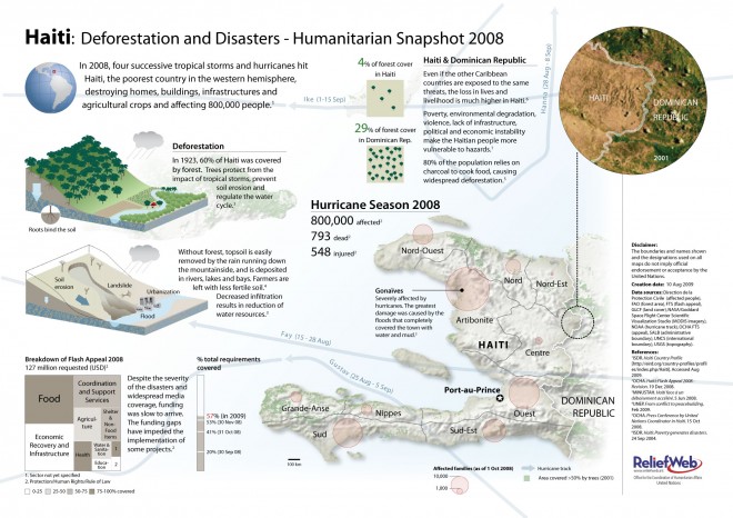
Map from the UN's ReliefWeb depicting the humanitarian challenges related to deforestation. The green areas on the map illustrate how little of Haiti is now forested.
Intentional deforestation, however, is far more devastating. Haiti, the poorest country in the western hemisphere, has had its tropical forests systematically stripped from the landscape over the past several decades. Small-scale, yet widespread, logging of the trees for energy has transformed the once-forested countryside into a barren landscape (estimated 60 percent tree cover in 1923 compared to only 2 percent in 2006).
When rain falls on the barren and steep landscape the soil is easily eroded (nearly two-thirds of Haiti has slopes of more than 20 percent). The consequences of deforestation-induced erosion are exacerbated in tropical areas such as Haiti where intense storms and hurricanes are common.
What happens to all the sediment when it's eroded from the hillsides? Whenever there is erosion of sediment it is balanced by deposition elsewhere. This is where Wdowinski and coauthors come in. They use estimates of the amount of sediment deposited on the Léogâne River delta over the past few decades to calculate an erosion rate in the mountainous area the river drains. The deposition and erosion rates were then integrated with a model of how the stresses on the fault zone change over time.
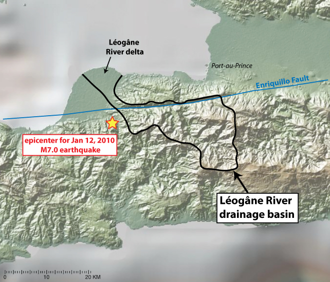
Topographic map of southern part of Haiti showing the Leogane River drainage basin and delta, the epicenter of the January 2010 earthquake, and the path of the main fault zone, the Enriquillo Fault.
Basemap created in GeoMapApp.
Earthquakes Triggered by Surface Processes?
When we think of earthquakes, we typically think about the large-scale tectonic forces driving one plate into or past another plate. What we experience at the surface — shaking and, if you're in the wrong place at the wrong time, rupture — is the manifestation of processes several miles or more deep in the crust. Surely, processes occurring on the surface of the Earth can't influence the timing of these deep-seated tectonic forces. Or, can they?
A Nature paper published in July 2010 by Calais and others discussed the possible relationship of Mississippi River incision to the timing of earthquakes on the New Madrid fault zone in the central United States. Much like the mechanism discussed here for Haiti, Calais and colleagues model the change in stress along the fault zone in response to removing surface mass through river erosion (although they discuss timescales of thousands of years instead of decades).
A 2003 paper by Dadson and colleagues, also published in Nature, discusses the link between erosion and seismicity on the mountainous and typhoon-ravaged island of Taiwan. A separate study of Taiwan concluded that so-called "slow" earthquakes are influenced by the change in atmospheric pressure from typhoons passing over the island.
To be clear, Wdowinski and coauthors are not saying that storm-induced sediment transfer of the deforested landscape is the underlying cause of the earthquake — rather, it is the trigger. Tectonic forces along the North American-Caribbean plate boundary build up stresses, which are released abruptly as earthquakes. In many cases, the trigger for that release is thought to be that the fault zone simply reaches a threshold. If you keep stretching a rubber band, at some point — snap! In other cases, distant earthquakes on other plate boundaries are thought to trigger earthquakes. Here, Wdowinski and coauthors are concluding that the movement of sediment from one area to another directly above the fault zone was sufficient enough to be the trigger.
Cause and Effect in a System of Systems
Causation is a thorny concept in systems where a chain of events produces an effect. Let's consider a Rube-Goldberg machine. These highly entertaining contraptions are a nice example of cause and effect in a complex system. In this fantastic video by the band OK Go, the final step of spraying paint on the band members is the big red ball rolling down a ramp, but it would never have occurred if any of the previous actions failed. Each successive event is contingent upon the preceding action. Is the cause the first step or the last step?

But this analogy is imperfect — or, at least, incomplete. Unlike the linear, step-by-step chain of actions in a Rube-Goldberg setup, cause and effect in Earth systems is distinctly nonlinear. Inputs and outputs may not be proportional: a cause with ever-so-slightly different parameters than the previous instance might result in a wildly different effect. Additionally, systems and their component sub-systems interact to produce feedback loops that can either amplify or stabilize resulting effects. Feedbacks blur the line of what is cause and what is effect. Perhaps a better way to think about it is that the Earth system is akin to millions of individual Rube-Goldberg machines of various sizes and degrees of complexity combined into a tangled and heaving mass of interdependent actions.
If the Haiti landscape was not so severely deforested would the earthquake still have occurred? Probably. But to what extent the transfer of surface mass influenced the timing and location of the earthquake is a fascinating question.
Testing the Hypothesis
One of the best aspects of the annual American Geophysical Union meeting is how Earth scientists use it to discuss their ideas. Even if your data are preliminary and there is much work to be done, it is a great venue to get input from other scientists about your hypothesis. I even tweeted this sentiment while attending the meeting.
In that spirit, here are some aspects of the Wdowinski et al. hypothesis I'd like to see addressed:
A more robust accounting of the history of deposition on the delta. The authors state that the delta has grown over the past 35 years, but I think this is just in area. Obtaining volumes and masses of sediment transferred from the mountains to the delta would require multiple sediment cores and other on-the-ground data.
How long does it take for sediment to go from where it was eroded in the hillside to the delta? My intuition tells me it gets flushed rather quickly, but this should be addressed.
How much sediment directly bypassed the delta and was transferred offshore? Similarly, how much sediment was deposited in the delta and then re-eroded some years later and transferred offshore? This could significantly affect the estimation of delta growth and, thus, the calculated erosion rate. (A research cruise similar to this one might be able to answer these questions.)
The authors chose the Léogâne River drainage basin for their study, which is appropriate given the location of the epicenter, but a more comprehensive account using multiple river systems would bolster the estimations of sediment mass transfer for the region.
How exactly was the erosion rate of 6 mm/yr calculated?
How was the threshold in the modeling of the stresses established? I have little expertise in this type of modeling so I welcome comments below.
This particular earthquake did not occur directly on the main fault (the Enriquillo Fault) but on another fault nearby. Is this complexity captured in the modeling?
I'm sure you could think of more. As I mentioned at the beginning of the post, I did not see the presentation from Wdowinski and colleagues so they very well may have addressed some or all of these issues.
The notion that Earth's systems interact in complex ways is intuitive, but we still have much to learn about these connections. Although preliminary, this example of how surface processes could influence much deeper processes is thought-provoking to say the least. Understanding the linkages between different components of the Earth system is challenging because it requires scientists to step outside of their specialty. But exploring these potentially surprising connections is also exciting.
-
* See the post at the blog Climate Progress, "Was the 2010 Haiti Earthquake Triggered by Deforestation and the 2008 Hurricanes?" where I first saw this story.
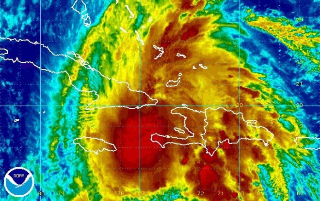
Images: 1) Hurricane Tomas passing between Haiti and Cuba in November 2010/NOAA. 2) Map and diagram from ReliefWenb.int. 3) Map of southern Haiti showing Léogâne River watershed and delta, and Jan. 12, 2010, earthquake epicenter. Created with GeoMapApp.org mapping tool (4) Rube Goldberg machine cartoon/Rube Goldberg
Full abstract of study presented at 2010 American Geophysical Union (AGU):
"Triggering of the 2010 Haiti earthquake by hurricanes and possibly deforestation"
Wdowinski, S., Tsukanov, I., Hong, S., and Amelung, F.
The Jan. 12, 2010, M = 7.0 Haiti earthquake was one of the worst natural disasters of the past century. This devastating earthquake caused the death of more than 200,000 people, the injury of about 300,000 people, and left about two million people homeless. Just a year and a half prior to the earthquake, Haiti was subjected to another severe disaster, flooding induced by two hurricanes and two tropical storms (Fay, Gustav, Hanna and Ike). Both natural disasters results in death and destruction, but because their origins are very different, they are generally considered to be unrelated phenomena. We suggest a physical link between these two destructive events, in which the 2010 Haiti earthquake was triggered by rapid erosion induced by hurricane activity. The suggested denudation triggering mechanism is consistent with seismic and geodetic analysis on the earthquake rupture, indicating an initial oblique motion on a southward dipping fault followed by intense reverse faulting on a northward dipping fault (Hayes et al., 2010). Our triggering analysis is based on interdisciplinary research using satellite imagery, bathymetric charts, detailed DEM, and 3-D mesh-free finite element modeling. Remote sensing analysis of the nearby Leogane Delta's growth over the past 35 years indicates a rapid delta build up due to a mean erosion rate of 6 mm/yr. Theoretical calculations based on finite element modeling and Coulomb failure stress criterion suggest that denudation-induced stress changes at the hypocenter reached the earthquake's triggering threshold (3 kPa) after 60-80 years at the present day erosion rate. Our results also suggest that the rapid sediment deposition in the delta kept clamping the northward dipping fault allowing a continuous stress build up on the fault, which explains the large amount of seismic energy released by this fault during the earthquake. Haiti's massive deforestation most likely contributed to the rapid erosion in the past several decades and the heavy tropical rains contribute to efficient sediment transport. The heavy rain poured during the 2008 hurricane season flushed the drainage system in the epicenter area and removed the last significant sediment load that triggered the 2010 Haiti earthquake.
Source: Wired
© 2010-2027 Bill McNulty All Rights Reserved